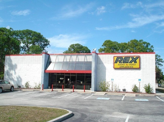
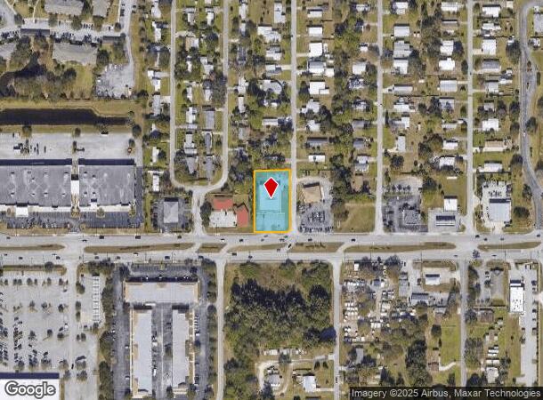
Property Record
4080 W New Haven Ave, Melbourne, FL 32904
NEARBY LISTINGS FOR SALE OR LEASE
Property Detail
4080 W New Haven Ave
Palm Bay-Melbourne-Titusville, FL
Paulana Mobile Home Subd
28-36-02-02-00000.0-0001.00
PAULANA MOBILE HOME SUBD LOT 1 EX HWY R/W
Storebuilding
Brevard
X
Florida
12009C0579G
1
2024
0.77 AC
2025
Brevard County
064601
Orlando
8,135 SF
DEMOGRAPHICS near 4080 W New Haven Ave
1 Mile
3 Mile
5 Mile
2024 Total Population
6,448
32,032
116,829
2029 Population
7,102
35,061
127,783
Pop Growth 2024-2029
+ 10.14%
+ 9.46%
+ 9.38%
Average Age
45
43
43
2024 Total Households
2,573
12,709
47,849
HH Growth 2024-2029
+ 9.91%
+ 9.21%
+ 9.25%
Median Household Inc
$76,585
$77,475
$62,540
Avg Household Size
2.30
2.40
2.30
2024 Avg HH Vehicles
2.00
2.00
2.00
Median Home Value
$291,666
$279,657
$237,700
Median Year Built
1987
1991
1987
Nearby Places
Map Layers
Map Styles
 Street
 Aerial
- Restaurants
- Banks
- Shops
- Fitness
- Groceries
PUBLIC TRANSPORTATION
AIRPORT
Melbourne Orlando International
DRIVE
WALK
Distance
Melbourne Orlando International
13 min
5.2 mi
Freight Ports
Port Canaveral
DRIVE
WALK
Distance
Port Canaveral
44 min
35.2 mi
Nearby Properties
Address
Land Use
TOTAL SIZE
Lot Size
Zoning
Address
Land Use
TOTAL SIZE
Lot Size
Zoning
433,669 SF
21.22 AC
AU
Address
Land Use
TOTAL SIZE
Lot Size
Zoning
506,643 SF
80 AC
RA
Address
Land Use
TOTAL SIZE
Lot Size
Zoning
425,167 SF
43.33 AC
Address
Land Use
TOTAL SIZE
Lot Size
Zoning
265,272 SF
21.17 AC
M1
Address
Land Use
TOTAL SIZE
Lot Size
Zoning
384,430 SF
33.07 AC
R2
Address
Land Use
TOTAL SIZE
Lot Size
Zoning
389,175 SF
12.18 AC
Address
Land Use
TOTAL SIZE
Lot Size
Zoning
387,843 SF
27.19 AC
R3
Address
Land Use
TOTAL SIZE
Lot Size
Zoning
197,734 SF
27.99 AC
M1
Address
Land Use
TOTAL SIZE
Lot Size
Zoning
297,886 SF
32.38 AC
C-1
Address
Land Use
TOTAL SIZE
Lot Size
Zoning
261,552 SF
23.21 AC
R2
Address
Land Use
TOTAL SIZE
Lot Size
Zoning
268,487 SF
20.08 AC
RA
Address
Land Use
TOTAL SIZE
Lot Size
Zoning
280,518 SF
13.88 AC
Address
Land Use
TOTAL SIZE
Lot Size
Zoning
542,262 SF
51.88 AC
CP
Address
Land Use
TOTAL SIZE
Lot Size
Zoning
226,121 SF
17.73 AC
Address
Land Use
TOTAL SIZE
Lot Size
Zoning
225,020 SF
24.25 AC
Address
Land Use
TOTAL SIZE
Lot Size
Zoning
196,130 SF
16 AC
Address
Land Use
TOTAL SIZE
Lot Size
Zoning
205,564 SF
14.56 AC
M1
Address
Land Use
TOTAL SIZE
Lot Size
Zoning
175,610 SF
10.01 AC
CCP(15)
Address
Land Use
TOTAL SIZE
Lot Size
Zoning
248,019 SF
12.22 AC
P1
Address
Land Use
TOTAL SIZE
Lot Size
Zoning
161,528 SF
13.23 AC
CP
Address
Land Use
TOTAL SIZE
Lot Size
Zoning
95,944 SF
17.22 AC
GU
Address
Land Use
TOTAL SIZE
Lot Size
Zoning
239,767 SF
24.47 AC
M1
Address
Land Use
TOTAL SIZE
Lot Size
Zoning
178,657 SF
19.46 AC
M1
Address
Land Use
TOTAL SIZE
Lot Size
Zoning
58,607 SF
2.79 AC
Address
Land Use
TOTAL SIZE
Lot Size
Zoning
108,896 SF
11 AC
RA
Address
Land Use
TOTAL SIZE
Lot Size
Zoning
163,449 SF
11.20 AC
M1
Address
Land Use
TOTAL SIZE
Lot Size
Zoning
130,907 SF
20 AC
M1
Address
Land Use
TOTAL SIZE
Lot Size
Zoning
193,940 SF
38.87 AC
Address
Land Use
TOTAL SIZE
Lot Size
Zoning
119,111 SF
6.88 AC
M1
Address
Land Use
TOTAL SIZE
Lot Size
Zoning
101,321 SF
9.30 AC
C1
The World's #1 Commercial Real Estate Marketplace
Connect with us
© 2025 CoStar Group
The information above has been obtained from sources believed reliable. While we do not doubt its accuracy we have not verified it and make no guarantee, warranty or representation about it. It is your responsibility to independently confirm its accuracy and completeness. Any projections, opinions, assumptions, or estimates used are for example only and do not represent the current or future performance of the property. The value of this transaction to you depends on tax and other factors which should be evaluated by your tax, financial, and legal advisors. You and your advisors should conduct a careful, independent investigation of the property to determine to your satisfaction the suitability of the property for your needs.